.png?width=268&height=52&name=f1-logo2%20(1).png)

 Interactive mapping can significantly benefit your school by enhancing operational efficiency and improving safety. These digital maps provide real-time, detailed visual representations of the school's layout, including classrooms, offices, maintenance areas, systems, assets, and equipment. Interactive maps streamline maintenance management by allowing for quick identification and reporting of issues, ensuring timely repairs, and reducing downtime. In emergencies, these maps aid in efficient coordination and evacuation, ensuring the safety of everyone on campus. Interactive maps support a more organized, responsive, and secure school environment.
What is an Interactive Map?
Interactive maps are facility blueprints and floor plans that have been transformed into digital maps. Facility management teams, faculty, and staff can use these interactive maps via computer, laptop, tablet, or smartphone. This transformation takes your school's standard paper or digital blueprints and floor plans. It turns them into an intuitive tool that provides quick access to digital maps, work orders, and asset information with the touch of a finger.
Key Features of Interactive Mapping Software
Interactive mapping for educational facilities has two key features that enhance their value, making them much more than just digital versions of existing blueprints or floorplans.
- Equipment Cards - This digital tool gives facility managers and technicians working in schools and colleges insight into specific pieces of equipment. Data collected and available through the maps includes the install date, warranty expiration date, upstream and downstream connectivity, associated work orders, replacement value, attached files, and more.
- Annotation Layers - Critical information that may not be available on your facility's original blueprints or floor plans can be added to interactive maps using an annotation layer tool. These customized digital layers are simple to add, view, and remove by facility managers and technicians. Evacuation routes, safe rooms, reunification areas, and room numbers are annotation layers that schools can use to display within an interactive mapping software system.
What are the Benefits of Interactive Mapping for your School?
The primary benefit of having interactive mapping software for your school is to keep an accurate and current representation of the school's layout. This mapping software makes it easy to note and record crucial changes due to new construction, renovations, or adjustments in emergency routes. Here are some additional benefits of having an interactive mapping system for your school:
- Centralize and streamline critical educational facility workflows
- Map and manage assets, zones, and systems within the facility
- Display system connectivity upstream and downstream
- Map and manage exact equipment locations throughout a school, district, or campus
- Manage vendor information, service contracts, and warranties
- Attach pictures, maintenance documents, and notes to any assets
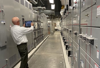
.png?width=423&height=250&name=Blog%20Graphics%20(4).png) Facilities, including private schools, public school districts, colleges, and universities, can benefit significantly from interactive maps. Facility managers and technicians can utilize this intuitive software to increase maintenance efficiency and enhance communication. Interactive maps used by educational facilities streamline workflows, allowing managers and technicians to easily view and edit work orders and asset data in an exact location.
Facilities, including private schools, public school districts, colleges, and universities, can benefit significantly from interactive maps. Facility managers and technicians can utilize this intuitive software to increase maintenance efficiency and enhance communication. Interactive maps used by educational facilities streamline workflows, allowing managers and technicians to easily view and edit work orders and asset data in an exact location.
Interactive mapping software also provides immediate access to critical information like zone and mechanical fire system data, allowing a plan of action to be swiftly executed in an emergency. Overall, interactive maps are created with crucial facility asset locations and information, creating a centralized and organized system for more efficient facility management and better student, staff, and faculty experiences.